
Archive Record
Images
Metadata
Object Name |
Map |
Title |
Accomac Quadrangle |
Object ID |
AA.409.05 |
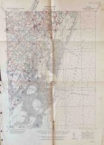
Description |
U.S. Army Corps of Engineers Tactical Map of the Accomac Quadrangle, Grid Zone "A" from 1919/1929. Quadrangle number is 2663:0650:/99. Map is based on the USGS & GS Charts Nos. 1221 and 129, Topographic Sheet No. 868, and an Accomack County soil map. The map shows Parramore Banks and the Atlantic Ocean to the east and Melfa and Onancock to the west. Shows Greenbush to the north and Polk Creek to the south. The towns of Greenbush, Accomac, Tasley, Onley, Onancock, Daugherty, Locustville, Melfa, Wachapreague, and Quinby are shown. Map includes roads, marshland, waterways, water depths, and building locations. Historic homes are dotted in red and numbered. Map was marked by Ralph Whitelaw to resemble the land tracts in his book "Virginia's Eastern Shore, Vol. II" with a red line to indicate tract borders and blue numbers for the matching tracts. This map shows tracts A18, 19, 40, 41, 42, 43, 44, 45, 46, 47, 48, 49, 54, 64-1, 65, 66a, 66b, 66c, 66d, 67, 68, 69, 69 1/2, 70, 71, 72, 73, 78-1, 78-2, 78-4, 78-6, 78-7, 83, 84, 85, 86, 87, 88, 89, 90, 90 1/2, 91, 92, 93, 94, 102, 103, and 104. Tract A38, 55, 64b, 78-3 are written in the western margin beyond the boundaries of the map. These numbers match the tract numbers Whitelaw assigned in his rough draft of the book and not the published version. |
Creator |
U.S. Army Corps. of Engineers |
People |
Whitelaw, Ralph T. |
Search Terms |
Accomac Daugherty Greenbush Land Locustville Map Melfa Metompkin Island Onancock Onley Parramore Island Quinby Tasley Wachapreague Whitelaw |
Subjects |
Map Roads Towns |
Year Range from |
1919 |
Year Range to |
1929 |