
Archive Record
Images
Metadata
Object Name |
Map |
Title |
Chincoteague Is. Quadrangle |
Object ID |
AA.409.03 |
Description |
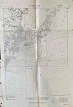
U.S. Army Corps of Engineers Tactical Map of the Chincoteague Island Quadrangle from 1919/1920. Quadrangle number is 2663:1700:/49. Map is based on the USGS & GS Charts Nos. 1221 and 128 and an Accomack County soil map. The map shows Chincoteague Island and the Atlantic Ocean to the east and Wallops Neck to the west. Shows Chincoteague Bay to the north and Assawoman Inlet to the south. The towns of Chincoteague, Silva, Sinnickson, Red Hills, Horntown, Wattsville, and Wishart are shown. Map includes roads, marshland, waterways, water depths, lighthouses, and building locations. Historic homes are dotted in red. Map was marked by Ralph Whitelaw to resemble the land tracts in his book "Virginia's Eastern Shore, Vol. II" with a black line to indicate tract borders and blue numbers for the matching tracts. This map shows tracts A135, 137, 138, 165, 166, 167, 168, 170, 172, 173, 174, 175, 176, 178, 179, 180, 181, 182, 183, and 184. Tracts A177 and 185 are written in the northern margin beyond the boundaries of the map. Tract A171 is written in the western margin beyond the boundaries of the map. These numbers match the tract numbers Whitelaw assigned in his rough draft of the book and not the published version. |
Creator |
U.S. Army Corps. of Engineers |
People |
Whitelaw, Ralph T. |
Search Terms |
Assateague Island Chincoteague Island Cockle Point Horntown Land Map Red Hill Silva Sinnickson Wallops Island Wattsville Whitelaw Wishart |
Subjects |
Map Roads Towns |
Year Range from |
1919 |
Year Range to |
1920 |