
Archive Record
Images
Metadata
Object Name |
Map |
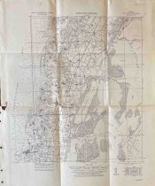
Title |
Eastville Quadrangle |
Object ID |
AA.409.07 |
Description |
U.S. Army Corps of Engineers Tactical Map of the Eastville Quadrangle, Grid Zone "A" from 1919/1928. Quadrangle number is 2653:7590:/63:0549. Map is based on the USGS & GS Charts Nos. 1221, 1222, 1223 and a Northampton County soil map. The map shows Cobb Island to the east and the Chesapeake Bay to the west. Shows Nassawadox to the north and Fairview to the south. The towns of Nassawadox, Franktown, Bayford, Thomas Wharf, Weirwood, Marionville, Red Bank, Birdsnest, Johnstown, Machipongo, Shadyside, Martins Siding, Kendall Grove, Eastville, Chesapeake, Cherrystone, Oyster, Cheriton, Bayview, Cape Charles, Fairview, and Seaview are shown. Map includes roads, marshland, waterways, water depths, and building locations. Map was marked by Ralph Whitelaw. Historic homes are dotted in red and numbered. |
Creator |
U.S. Army Corps. of Engineers |
People |
Whitelaw, Ralph T. |
Search Terms |
Bayford Birdsnest Bridgetown Cape Charles Cheriton Cherrystone Chesapeake Cobb Island Eastville Fairview Franktown Johnstown Kendall Grove Land Machipongo Map Marionville Martins Siding Nassawadox Oyster Red Bank Seaview Shadyside Thomas Wharf Weirwood Whitelaw |
Subjects |
Map Roads Towns |
Year Range from |
1919 |
Year Range to |
1928 |