
Photo Record
Images
Metadata
Object Name |
Print, Photographic |
Title |
Wallops Flight Facility Aerial Photo |
Object ID |
A2003.011.007 |
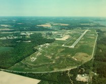
Description |
Aerial photo of an overview of Wallops Flight Facility. Photo shows almost the entirety of the facility, the NOAA station and satellites, three run ways, and Chincoteague Road. Horntown Bay visible in the right background. Photo was taken while facing north. |
Place |
Wallops Island, VA |
Search Terms |
NASA Space Wallops Flight Facility Wallops Island |
Subjects |
Science NASA |
Year Range from |
1988 |