
Object Record
Images

Metadata
Object Name |
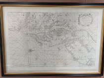
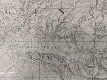
Map |
Title |
Chesapeake & Delaware Bay Sailor's Map |
Object ID |
1998.005.001 |
Date |
1689-1705 |
Description |
Ship's chart of "Virginia, Maryland, Pennsylvania, East and West New Jersey." Image from 1689-1705, Print dated 1740's. Chart from "The English Pilot." Seal reads "Sold by: Mount. & Tho. Page. Tower Hill." The principal chart used aboard merchant vessels plying the waters of the Chesapeake and Delaware bays in the late Seventeenth and early Eighteenth centuries was John Thornton and William Fishers's "Virginia, Maryland, Pennsylvania, East and West New Jersey." Water depths are depicted as are such hazards to navigation as shoals and sandbars. Based closely on the earlier map of Augstine Herrman, Thornton and Fisher's chart was published between 1689-1794 in thirty seven editions of "The English Pilot, the Fourth Book." This popular atlas of American waters was the fourth of five volumes that made up the "English Pilot," the first great English sea atlas. -Source: Stephenson, Richard W. Marianne M. McKee, ed. "Virginia In Maps: Four Centuries of Settlement, Growth, and Development." Richmond, VA: The Library of Virginia, 2000. |
Collection |
Museum Objects |
Search Terms |
Chesapeake Bay Map Virginia Maryland Pennsylvania New Jersey |
Subjects |
Maritime Sailing Boat |